Research Topics
The Institute for Communications and Navigation contributes to the foundation of satellite navigation and its applications, and to the synergy of communication and navigation. A substantial part of the work is closely related to Galileo, the European Global Navigation Satellite System.
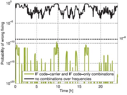
Integer Ambiguity Resolution
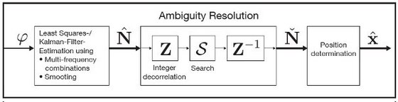
Carrier phase measurements are extremely accurate but ambiguous. The latter ambiguity arises from the periodicity of the carrier phase signal. This integer number of cycles between the satellite and receiver has to be estimated with measurements from multiple epochs and/ or code measurements. The reliability of ambiguity resolution was improved by the institute by more than 9 orders of magnitude with the help of new multi-frequency code carrier linear combinations.
The following research topics are addressed:
- Reliable integer ambiguity resolution
- Phase and code bias estimation
- Ionosphere and multipath mitigation
Joint Tracking Receiver
Precise positioning methods require the simultaneous reliable tracking of the carrier phase on several frequencies and from several satellites. Phase locked loops (PLL) perform independent tracking of the carrier phase on every satellite. They loose lock when the corresponding satellite suffers from shadowing or strong ionospheric scintillations. Joint tracking algorithms make use of the spatial and spectral correlation of the received signals. The following benefits have been confirmed
- Significant noise attenuation
- Strong reduction of the number of cycle slips
- No need for re-acquisition after signal interruptions
Measurement Campaigns
The Institute is performing regular measurement campaigns to test and evaluate the algorithms invented at the university. In December 2008 the institute conducted two test-flights with a Beechcraft King Air 350 airplane starting in Braunschweig. The flights were operated by the project partner FCS (Flight Calibration Services) and included several touch-and-go's, steep approaches, and banking maneuvers.


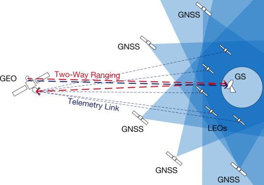
Precise Point Positioning of Geostationary Data Relays
A large number of satellites (ca. 400) are used for earth observation. Due to the increasing resolution of their instruments, they produce large data volumes, while being only shortly visible at antenna sites. Furthermore, the data needs currently to be stored and is thus delayed by up to ca. 90 Minutes. These problems are resolved by relaying the data via a geostationary satellite. Such an alternative is currently developed under the lead of the DLR in the GeReLEO project - Geostationary Data Relay for Low Earth Orbit Satellites.
GEO satellites are orbiting above GNSS constellations and therefore are positioned by ranging measurements from ground. This usually leads to accuracies in the range of 1-2 km.
The data flow from the LEO satellites via the GEO satellite to the ground allows to investigate a new concept of precise positioning of geostationary data relays: Thereby, LEO satellites positioned with GNSS services serve as navigation satellites for the GEO satellite. Navigation messages added to the telemetry data allows determining the LEO-GEO-Ground pseudoranges on ground. A two-way ranging between the ground station and the GEO satellite enables to eliminate the GEO-Ground part of the pseudoranges. By post processing on ground, a GEO position with centimetre accuracy can be estimated.